Can you swim in Nha Trang today? Check the sea conditions
For travelers already in Nha Trang or planning to visit the beach today, this guide explains how to read the latest wave, wind, rain, and UV forecasts. It also covers the warning signs that mean you should stay out of the water.
Check sea conditionsWritten by Tụi mình mê biểnUpdated

Photo: Hoàng Thạch
Before deciding whether to swim in Nha Trang today, check the tool's recommendation, then look at three numbers: wave height, wind speed, and rainfall. Thunderstorms, waves of 1.5 meters, winds of 30 km/h, or 5 mm of rain within the displayed data interval all make the tool advise against entering the water. Even when the forecast looks favorable, you still need to check beach warning flags and follow lifeguard instructions.
Nha Trang sea conditions today
A reference score built from Open-Meteo wave, wind, rain and UV data
Updating sea conditions…
This score is for reference only. Before swimming, check the warning flags on the beach, follow lifeguard instructions and keep an eye on official forecasts - in the rough season (Sep-Dec) the sea can change quickly.
How to check Nha Trang's sea conditions today
The Nha Trang sea conditions tool uses weather and marine forecast data from Open-Meteo. You don't need to enter a location, choose a date, or adjust any settings. The data loads automatically when you open the page.
At the top, you'll see a score box labeled "Reference score" on a scale from 0 to 10. This summarizes how favorable the current weather and sea conditions appear according to the tool's scoring rules.
A short recommendation appears alongside the score, giving you a quick idea of whether conditions look suitable or whether there are reasons to avoid swimming.
Below that are six measurements:
| Indicator | What it tells you |
|---|---|
| Air temperature | How warm or cool the weather is |
| Wind speed | How strong the wind is |
| Modelled significant wave height | The wave height predicted by the marine model |
| Sea temperature | How warm or cool the sea water is |
| UV | How strong the sun's ultraviolet radiation is |
| Model-estimated precipitation | Model-estimated rain during the displayed time interval |
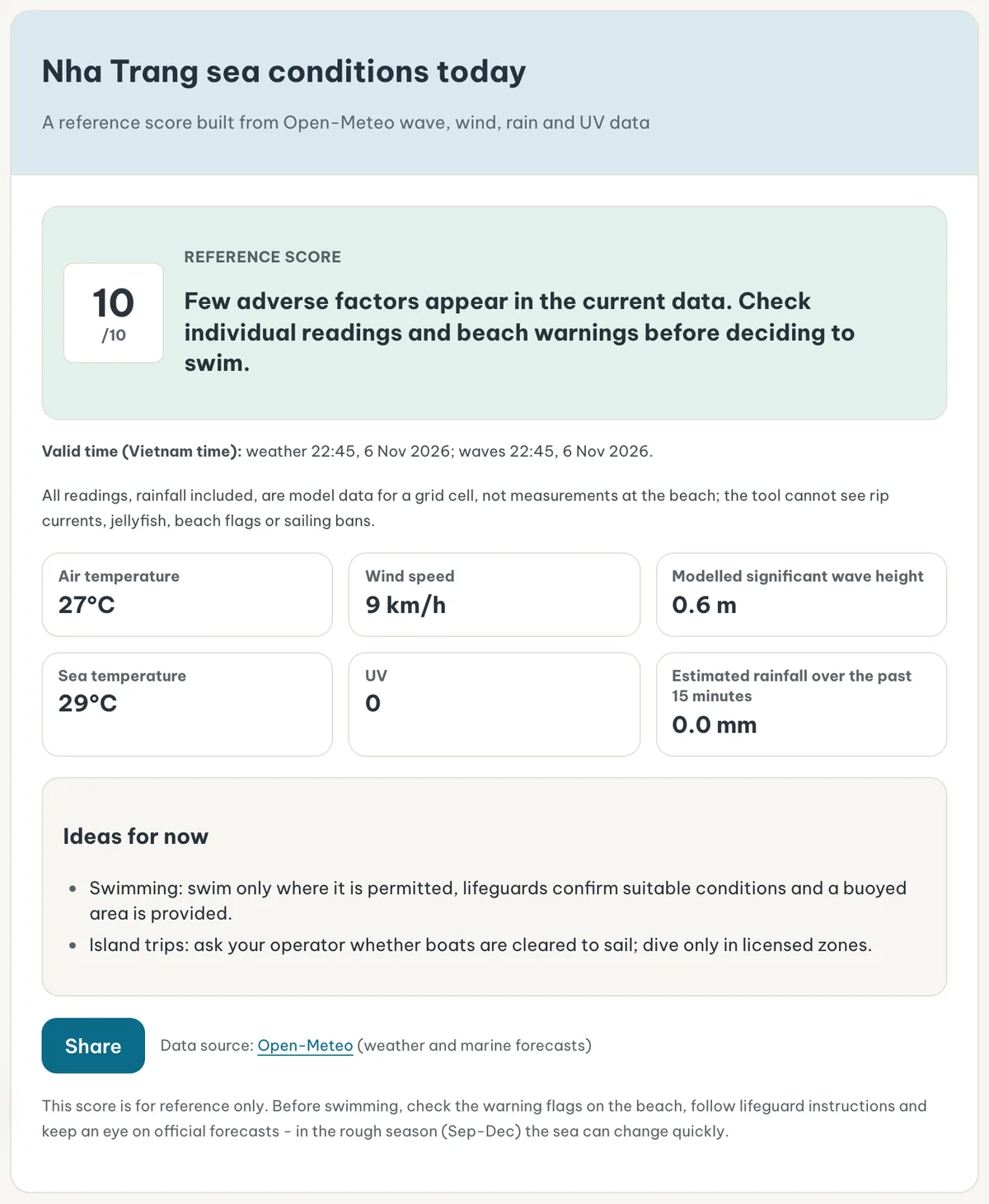
Read the results in this order: recommendation, reference score, data validity time, and individual measurements.
Don't judge swimming conditions by temperature alone.
A sunny 30°C day can still have strong winds and rough waves. Conversely, a cloudy morning doesn't necessarily mean the sea is rough.
The score isn't a swimming safety certificate. It only combines the conditions available from the forecasting models. Rip currents, local swimming restrictions, and lifeguard warnings must be checked separately.
Where does the Nha Trang sea forecast come from?
The tool retrieves forecasts for an area around 12.24°N latitude and 109.19°E longitude, near Nha Trang.
These coordinates serve as a reference point for the forecast. They aren't the location of a physical wave-measuring device.
Open-Meteo uses numerical weather and marine models, returning data from a model grid cell associated with the requested coordinates.
The actual center of that grid cell may be several kilometers away from the original reference point. Weather and marine models can also have different spatial resolutions.
For example, suppose the tool displays a significant wave height of 0.8 meters.
That doesn't mean every wave reaching Tran Phu Beach is exactly 0.8 meters high. It means the marine model estimates a significant wave height of around 0.8 meters for the selected grid cell.
This distinction matters even more when you're planning an island trip.
A beach sheltered by the bay, a coastline directly exposed to the wind, and a stretch of water near an island can experience different conditions.
Waves farther offshore may also differ from those breaking along the beach.
The tool is useful for understanding general conditions around Nha Trang. It doesn't provide a separate assessment for every beach, island, or boat route.
Always check the forecast's valid time
Below the recommendation, the tool displays "Valid time (Vietnam time)" with one time for weather and one for waves.
Pay attention to both timestamps.
Weather information and marine forecasts may come from different models with different update schedules.
For example, the weather figures might be valid for 8:00 AM while the wave forecast refers to 7:00 AM.
That doesn't mean every measurement was taken at exactly 8:00 AM.
Vietnam uses UTC+7 throughout the year. Compare the displayed timestamps with the time you're planning to swim or board a boat.
Also, Open-Meteo's current-condition data is based on numerical models. It isn't necessarily a direct, second-by-second observation from a monitoring station on Nha Trang Beach.
When conditions are changing quickly, the difference between the data's valid time and the time you actually use it becomes especially important.
What does the 0-10 reference score mean?
The tool starts with a score of 10 and deducts points for factors such as rainfall, wind, waves, weather codes, and UV above 10.
The resulting number describes how favorable the modeled conditions appear.
It is the tool's own reference scale, not an official swimming safety rating issued by Vietnamese authorities or lifeguard organizations.
| Score | Meaning | What to consider |
|---|---|---|
| 8-10 | Most favorable conditions on the scale | Swimming may be reasonable in a permitted, lifeguard-supervised area |
| 6-7 | Fairly favorable | Check individual measurements and actual beach conditions |
| 4-5 | Several unfavorable factors | Consider spending time on land instead |
| Below 4 | Multiple unfavorable factors | Avoid making swimming your main activity |
A score of 8 doesn't mean the sea is 80% safe.
Even a perfect 10 cannot guarantee there are no rip currents, unexpected waves, or local hazards.
The tool's recommendation can be more restrictive than its numerical score.
Some conditions trigger a warning regardless of the overall score.
For that reason, never make your decision based on the number inside the circle alone.
When the tool displays "Thunderstorm"
The tool treats weather codes 95, 96, and 99 as thunderstorm conditions.
When one of these codes is reported, the normal reference score is replaced with a "Thunderstorm" label and advice not to enter the water or head out to sea.
You don't need to keep comparing wave height and sea temperature in this situation.
When the tool displays "No wave data"
The message "No wave data" appears when the tool cannot retrieve the wave information it needs.
It does not mean the sea is calm.
Missing data simply means the tool lacks enough information to produce its normal assessment.
For example, light wind and no rain don't rule out waves generated by distant weather systems.
If wave data is unavailable, check conditions at the beach and ask local lifeguards or your tour operator before making a decision.
Understanding the six sea and weather indicators
Significant wave height: the first number to check
This is one of the most important measurements when you search for "Nha Trang waves today" or wonder whether the sea is rough.
The box is labeled "Modelled significant wave height", and significant wave height is a standard term in marine forecasting.
Significant wave height is approximately the average height of the highest one-third of waves observed or modeled over a given period.
It isn't the average height of every wave, and it doesn't describe the exact size of each wave that reaches the shore.
Some individual waves can be considerably higher than the reported significant wave height.
Suppose the displayed value is 0.7 meters.
You should understand this as a modeled significant wave height of approximately 0.7 meters for the selected area.
It doesn't mean every breaking wave will be 70 centimeters high.
Likewise, a value of zero, should one appear, wouldn't be absolute proof that the sea is completely still or free from dangerous water movement.
The tool's main wave threshold is 1.5 meters.
When significant wave height reaches or exceeds 1.5 meters, the recommendation changes to advise against swimming, even if the overall score remains relatively high.
This is a precautionary threshold used by the tool. It isn't a universal legal limit for every beach or marine activity.
Waves below 1.5 meters aren't automatically safe either.
Children, weak swimmers, and people unfamiliar with open-water swimming may struggle in conditions that experienced swimmers consider manageable.
Wave direction, wave period, seabed shape, and currents also influence what happens at the beach. The tool doesn't provide a complete assessment of these factors.

Photo: cloud.shepherd (Brian Miner)
Wind speed: calm-looking water can still be windy
Wind speed is displayed in kilometers per hour.
Strong wind can create choppy water, make swimming more tiring, and reduce comfort aboard smaller boats.
It's also a useful measurement when deciding whether to join an island tour.
Boat operations depend on conditions along the route, vessel capabilities, and the operator's safety decisions.
The tool uses 30 km/h as its wind warning threshold.
At or above this speed, its recommendation is not to enter the water.
For example, suppose waves are 0.6 meters high but wind speed is 32 km/h.
You shouldn't focus only on the relatively low wave height. The wind has already crossed the tool's warning threshold.
Sustained wind speed and wind gusts are different numbers.
Gusts are short increases in wind speed that may be considerably stronger than the general wind measurement.
The "Wind speed" box doesn't provide a complete description of every gust affecting the beach.
A sheltered section of coastline and exposed waters outside the bay may experience different wind conditions.
That's why you should confirm your boat trip directly with the operator, even when the weather around your hotel seems pleasant.
Rainfall: pay attention to the time interval
The rainfall box shows precipitation in millimeters for the time interval associated with the data.
Its label is usually "Estimated rainfall over the past 15 minutes", and the interval follows the data the tool receives. If no interval is available, the box reads "Model-estimated precipitation".
This detail is easy to overlook.
A screen showing 2 mm during the past 15 minutes doesn't mean 2 mm of rain has fallen throughout the entire day.
You also shouldn't automatically interpret it as an hourly rainfall total.
Similarly, a value of zero for a recent interval doesn't guarantee that rain won't start in the next half hour.
The tool advises against swimming when rainfall is 5 mm or more within the interval being evaluated. A heavy-rain weather code triggers the same advice.
That 5 mm threshold must be understood in relation to the displayed time interval.
Don't assume it means 5 mm per day or 5 mm per hour.
Model precipitation data comes in hourly and 15-minute versions. Where direct 15-minute model output is unavailable, shorter-interval values may be derived from hourly forecasts.
The result is therefore a model estimate, not necessarily a measurement from a rain gauge on the beach.
If heavy rain has already started, visibility is poor, or thunder is audible, don't wait for the next forecast update before leaving the water.
Air temperature: useful for planning your beach time
Air temperature shows how warm or cool the weather is, measured in degrees Celsius.
It's useful when deciding when to walk along the beach, spend time in the sun, or bring children outdoors.
An air temperature of 30°C doesn't mean the sea water is also 30°C. These are separate measurements.
Hot weather also doesn't guarantee good swimming conditions.
A sunny afternoon may still have strong wind, rough water, or very high UV exposure.
Avoid choosing your swimming time based only on comfortable air temperatures.
Check temperature alongside the wind, rainfall, and UV readings.
Air temperature helps you prepare for being outside, while the other indicators are more important when deciding whether to enter the water.
Sea temperature: is the water warm?
The "Sea temperature" box shows the temperature of the upper layer of seawater according to the model.
It can help you understand whether the water is relatively warm or cool.
This is useful when traveling with children or anyone who isn't accustomed to swimming in the sea.
However, the number isn't a direct measurement at the exact spot where you're standing.
Shallow water close to shore can be influenced by sunshine, rainfall, currents, and other local conditions.
Water temperature also tells you nothing about rip currents, strong waves, or jellyfish.
Warm water cannot compensate for dangerous sea conditions.
Use this measurement to help plan what to wear and how long to spend in the water, not as your main swimming safety indicator.
UV: calm seas don't make midday sun safe
UV measures the strength of ultraviolet radiation from the sun.
Higher values mean a greater risk of damage to your skin and eyes from sun exposure.
The general UV categories are:
| UV | Level | What it means |
|---|---|---|
| 0-2 | Low | Relatively low UV exposure risk |
| 3-5 | Moderate | Sun protection is recommended outdoors |
| 6-7 | High | Seek shade, particularly around midday |
| 8-10 | Very high | Avoid unnecessary exposure to midday sun |
| 11+ | Extreme | Take extra precautions and limit direct exposure |
The tool includes an additional reminder: when UV is above 8, it advises avoiding the sun between 10:00 AM and 3:00 PM.
This is a sun-exposure warning, not a statement that waves are dangerous.
For example, suppose the sea is calm, the wind is light, and no rain is reported, but UV is 9.
Marine conditions may look favorable, yet spending a long time under direct midday sunlight would still be a poor choice.
Don't ignore UV simply because the sky is cloudy. Cloud cover doesn't always block ultraviolet radiation effectively.
Three conditions that trigger a no-swimming recommendation
Apart from thunderstorms and missing wave data, the tool has three direct warning thresholds.
| Indicator | Threshold | Recommendation |
|---|---|---|
| Modelled significant wave height | 1.5 m or higher | Avoid swimming |
| Wind speed | 30 km/h or higher | Avoid swimming |
| Model-estimated precipitation | 5 mm or higher within the evaluated data interval, or a heavy-rain weather code | Avoid swimming |
Only one of these conditions needs to cross its threshold to trigger the warning, even when the other measurements appear favorable.
For example, waves might reach 1.6 meters while wind speed stays at 12 km/h and rainfall remains zero.
The low wind speed doesn't cancel out the wave warning.
Or waves might be only 0.5 meters high, but rainfall reaches 5 mm within the relevant interval.
The tool will still advise against swimming.
These rules prevent a relatively high overall score from hiding a significant unfavorable factor.
However, the reverse isn't true.
Staying below all three thresholds doesn't prove that a beach is safe.
The thresholds are part of the tool's reference system, not official swimming regulations or a replacement for local safety assessments.
Four examples of how to read the results
The following examples use hypothetical values to demonstrate how the tool works. They are not actual forecasts for Nha Trang on the day you're reading this article.
Example 1: generally favorable sea conditions
Reference score 9/10
Suppose the tool shows:
- Reference score: 9/10.
- Significant wave height: 0.4 m.
- Wind speed: 10 km/h.
- Rainfall: 0 mm during the displayed interval.
- UV: 3.
- No thunderstorm warning.
The modeled conditions appear fairly favorable.
You could consider visiting Tran Phu Beach, provided you choose a permitted swimming area with lifeguards and boundary buoys.
Before entering the water, observe the actual waves, check warning flags, and ask a lifeguard if you're unsure.
It's also a reasonable time to contact your island tour operator and confirm its schedule.
The tool's results don't guarantee that a boat will depart.
Example 2: sunny weather but high waves
Wave height 1.7 m
Suppose the air temperature is 29°C, UV is 5, rainfall is zero, and wind speed is 15 km/h.
However, significant wave height reaches 1.7 meters.
Despite the pleasant weather, wave height has exceeded the tool's 1.5-meter threshold.
You should avoid entering the water.
Ask your island tour operator whether the trip will run and what happens if conditions are unsuitable.
Sunshine on land doesn't mean the sea will be comfortable or safe.
Example 3: low waves but heavy rain
Rainfall 6 mm in the interval
Suppose wave height is 0.5 meters and wind speed is 14 km/h, but rainfall reaches 6 mm during the displayed interval.
The tool's rainfall threshold has been crossed.
It's better to switch to an indoor activity or somewhere with suitable shelter.
Once conditions improve, open the tool again and check the updated information.
Having changed into your swimsuit or traveled to the beach is no reason to swim.
Example 4: calm seas but very high UV
UV 10
Suppose waves are 0.3 meters, wind speed is 9 km/h, rainfall is zero, and UV is 10.
The wind, wave, and rain readings look favorable, but UV exposure is very high.
A sensible choice is to avoid spending time in direct sunlight between 10:00 AM and 3:00 PM.
You can consider swimming at a less sunny time, provided you check the sea conditions again before going.
A lower UV later in the day doesn't guarantee that wind and waves will remain unchanged.
Is it raining in Nha Trang today?
To answer this question, check the estimated rainfall, the weather conditions reflected in the recommendation, and the data's valid time.
A rainfall value above zero indicates that the model estimates precipitation during the corresponding interval.
It doesn't guarantee that rain is falling at your exact location.
Nha Trang has a long coastline and surrounding island waters. Rain can affect different areas at different times.
A shower might develop offshore while the beach near your hotel stays dry.
The opposite can also happen.
This is why it's useful to combine the tool's information with what you can actually see outside.
There are three important distinctions.
First, recent rainfall doesn't mean it will continue raining. A rainfall total for one interval isn't a forecast for the rest of the day.
Second, no rainfall doesn't mean calm seas. Waves can travel from distant weather systems even when the immediate Nha Trang area is dry.
Third, thunderstorms are different from ordinary showers. Stay out of the sea on any thunderstorm report from the tool, and at the first thunder or lightning.
A short walk or photos from the shore leave you more flexibility than a swim does.
However, lightning or severe weather warnings are reasons to leave exposed beach areas and find appropriate shelter.
Does Nha Trang have waves? Why appearance isn't enough
The sea around Nha Trang is always moving, but wave conditions change with the weather and location.
On some days, the water looks relatively flat from the shore.
On others, breaking waves and whitecaps are clearly visible, especially along exposed sections of coastline.
But "Are there waves?" and "Is it safe to swim?" are different questions.
Small waves don't necessarily mean weak currents.
A beach that appears calm can still have dangerous rip currents.
A rip current is a relatively narrow, fast-moving flow of water traveling away from shore.
It can carry swimmers out into deeper water, including people who are reasonably confident in swimming pools.
Rip currents don't always produce large, obvious waves.
The current Nha Trang sea conditions tool doesn't directly forecast rip currents at individual swimming locations.
It also doesn't provide a complete picture of local wave period, wave direction, or nearshore water movement.
For these reasons, don't assume you can safely swim far offshore simply because the water looks calm.
Choose a supervised swimming area with clear boundary markers.
Avoid swimming beyond the buoys or entering unfamiliar sections of coastline where you don't understand the underwater terrain.
If you're caught in a rip current, don't exhaust yourself trying to swim directly against it.
Try to remain calm, float if necessary, swim parallel to the shore when possible, and signal for help.
These are general safety principles. Avoiding dangerous conditions in the first place remains the better approach.
Using the tool before visiting Tran Phu Beach
Tran Phu Beach is the main urban beachfront that many visitors associate with Nha Trang.
A hotel near the coast may give you a view of the water from your room, or a short walk to the beach.
But looking out from your balcony won't reveal every current or local swimming restriction.
- Before you go
Open the tool
Before getting changed and carrying your belongings down to the sand, open the tool and read the latest available results.
- Read results
Recommendation, limits, UV
Start with the recommendation and check wave height, wind speed, and rainfall.
Then look at UV to help decide when to spend time outdoors.
- At the beach
Check on the spot
Once you reach the beach, check the actual conditions.
One section of the beach might be open for swimming while another is restricted.
Because the tool uses a model grid cell around Nha Trang, it doesn't know the exact stretch of Tran Phu Beach where you're standing.
Children need a supervised area suited to their swimming ability.
A calm-looking sea is no reason to let children enter the water without close adult supervision.
Likewise, don't assume a confident swimmer can safely lead an entire group far from shore.
Swimming in a pool and handling surf or currents in open water require different skills.
Can you use the forecast before booking a Nha Trang island tour?
Yes, the tool can help you understand general sea conditions before booking or departing on an island tour.
However, it cannot confirm whether a particular boat route is safe or officially permitted to operate.
Suppose you're considering a visit to Hon Tam or another island destination in Nha Trang Bay.
Low waves, light winds, and little rainfall are useful signs.
They suggest that the factors evaluated by the tool are relatively favorable around its reference area.
However, the tool doesn't produce a separate forecast for every section of the boat journey.
It doesn't know the condition of an individual vessel, the operator's safety assessment, anchoring arrangements, or the latest restrictions issued by the relevant authorities.
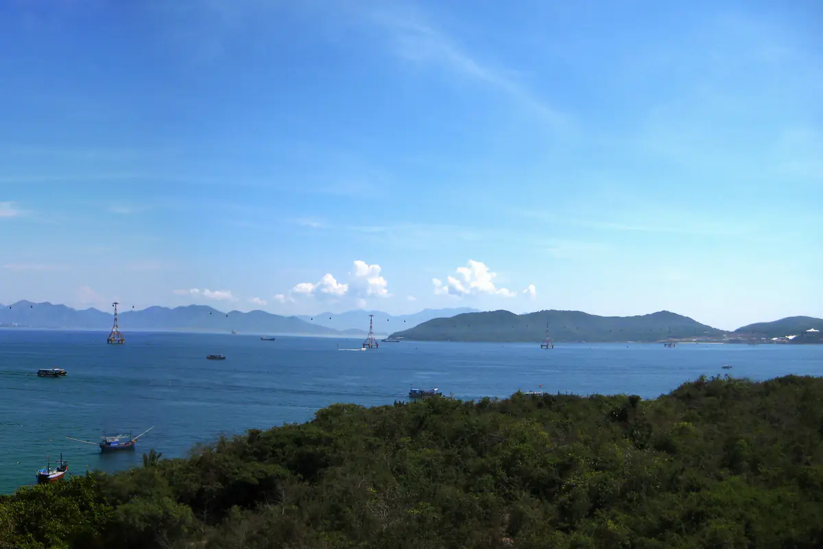
Photo: Quân Chu Hoàng
Contact the operator before the meeting time of any tour you've already paid for.
Ask whether the trip is running normally, whether any stops have changed, and what happens if conditions are unsuitable.
A reference score of 8, 9, or 10 doesn't guarantee departure.
Tour operators may adjust or cancel activities because of actual sea conditions or safety requirements, even when it's sunny on land.
Likewise, an unfavorable score doesn't necessarily mean every marine activity has been legally prohibited.
The tool provides guidance. Official operational decisions depend on the applicable regulations and conditions of the particular trip.
Check the operator's cancellation, rescheduling, and refund policy before paying.
What can't the sea conditions tool detect?
Some important beach hazards cannot be identified through the six displayed measurements.
Rip currents: General wave forecasts don't identify the exact location or strength of dangerous currents along an individual beach.
Jellyfish and other marine life: The tool doesn't track jellyfish, marine organisms, or other biological hazards that might affect swimmers.
Local warning flags: The system cannot see the flags, warning signs, or temporary swimming restrictions currently posted at the beach.
Official restrictions: The tool doesn't directly monitor government orders restricting marine activities or closing sea areas.
Individual breaking waves: Significant wave height from a marine model isn't a direct measurement of each wave breaking where you intend to swim.
Forecast uncertainty also matters.
Small differences in location, coastal geography, and timing can produce actual conditions that differ from a model's estimates.
This isn't unique to Nha Trang. Every numerical marine forecast has limitations involving spatial resolution, time resolution, and the representation of local phenomena.
During the rougher sea season, particularly from September through December, conditions can change quickly.
Check the latest available information shortly before your activity instead of relying on a result from the previous day.
Seasonal patterns are useful when choosing which month to visit Nha Trang, but they don't answer whether you should swim at a particular moment.
For that, current forecasts and on-site warnings matter more.
What should you do when sea conditions are unfavorable?
The tool includes an "Ideas for now" section that changes according to the forecast results.
At a reference score of 8 or higher, it suggests swimming only where it is permitted, lifeguards confirm suitable conditions and a buoyed area is provided, and asking your operator whether boats are cleared to sail. At 6-7, it suggests swimming under the same conditions plus browsing Dam Market.
When a warning limit is crossed or the score is below 6, the suggestions shift toward activities on land: mud baths and Dam Market, plus the Oceanographic Museum when rain is reported.
In Nha Trang, there are three practical alternatives.
Mud baths

Photo: MerPerle
Mud baths are a good option when you want to relax without depending on sea conditions.
Nha Trang has established mud-bathing facilities, but you should check the opening hours and availability of the specific facility before visiting.
Bad weather may affect travel and outdoor areas within a complex, so don't assume every service will operate normally.
Oceanographic Museum

Photo: Phương Huy
The Oceanographic Museum suits an interest in marine life, preserved specimens, and ocean science.
It's also a useful option for families who want something more educational than another beach visit.
Check the current visitor hours before leaving your hotel.
Dam Market

Photo: Christophe95
Dam Market is an option for browsing local goods, shopping, or seeing an established part of Nha Trang's commercial life.
It's particularly suitable when you'd rather spend time shopping than swimming.
However, heavy rain can still make getting around inconvenient, especially when walking between uncovered areas.
These alternatives aren't guarantees that every attraction will be open or suitable during severe weather.
A very high UV Index alone may not call for changing your entire itinerary.
Instead, consider moving your beach visit to a less sunny time and checking the forecast again.
Thunderstorm reports call for genuinely sheltered indoor activities, not a move from swimming to another exposed outdoor location.
When should you check the wave and weather forecast?
For someone already staying in Nha Trang, the most useful time to check the tool is shortly before leaving for the beach.
For island tours, check the forecast before making your booking decision and again close to departure.
You should also confirm the trip directly with the operator.
For an afternoon swim, don't rely on a morning forecast without looking again.
Winds, waves, and rainfall can all change over the course of a day.
There is no fixed number of minutes that makes a model forecast perfectly reliable.
Check reasonably close to your planned activity and verify conditions on arrival.
Rapidly changing weather means reassessing before entering the water.
When a clear hazard or warning is present, don't try to squeeze in a quick swim between two periods of bad weather.
What if the tool doesn't load?
Normally, the tool retrieves the latest available data automatically when the page opens.
If the internet connection fails or the data request cannot be completed, the page displays an error message and a "Try again" button.
Check your internet connection and select the button to try loading the data again.
Until fresh results are available, don't rely on numbers remembered from a previous visit to the page.
A network error doesn't tell you whether sea conditions are good or bad. It simply means the system hasn't retrieved the information it needs.
A loading error is not the same as the "No wave data" message.
A loading error may result from connectivity or a failed request.
The "No wave data" status indicates that the tool doesn't have enough wave information to produce its normal assessment.
If retrying doesn't work, check another marine forecast source and ask local lifeguards or your tour operator.
Avoid making swimming decisions based on incomplete data.
Sharing Nha Trang sea conditions with your group
The tool includes a "Share" button.
It allows you to send a short summary of the current conditions together with a link to the page.
This can be helpful when you're traveling with friends or family and everyone wants to review the forecast before leaving.
Devices with direct sharing let you choose the application that receives the information.
The button briefly changes to "Link copied!" once the link is copied, on devices where sharing falls back to copying.
There is one important limitation.
The page link isn't a permanent snapshot of the original forecast.
When someone opens it later, the tool retrieves data for that later time.
The reference score and individual readings may therefore be different from those you saw when sharing.
When discussing your plans, make sure everyone understands which time the information refers to.
For example, the group could use a 7:00 AM result to discuss a morning beach visit.
A trip postponed until the afternoon needs everyone to check again.
Don't forward a message saying "conditions are favorable" as though it guarantees safe swimming for the rest of the day.
What else should you check before entering the water?
After reviewing the forecast, there's still one essential step: checking the beach itself.
Look for warning flags and signs.
Identify the area marked by swimming buoys.
Watch how waves are breaking near shore, and listen to lifeguard instructions.

Photo: Christophe95
Don't enter an area where swimming is prohibited, even if the tool displays a score of 10.
Ask a lifeguard or the responsible beach staff what the warning flags at a particular beach mean.
Don't guess based solely on their colors.
Weaker swimmers should avoid unsupervised or unfamiliar stretches of beach.
Traveling with friends isn't a substitute for professional lifeguard supervision.
If you notice unusually powerful waves, strong currents, deteriorating visibility, or approaching thunderstorms, leave the water and move to safety.
For boat trips, the final decision also depends on the vessel, the route, official requirements, and the operator's assessment.
A favorable forecast is useful for planning.
It doesn't give anyone permission to ignore actual hazards, official restrictions, or instructions to stop an activity.
That limit matters more than any other when using a sea forecasting tool.
Final decision: swim, book an island tour, or change plans?
For a swim at Tran Phu Beach, look for low waves, light winds, little rain, and no thunderstorms, then confirm that swimming is permitted and lifeguards are present. For island tours, check the same indicators and confirm departure directly with the operator. Waves of 1.5 meters, winds of 30 km/h, 5 mm of rain in the evaluated interval, or a thunderstorm report all point to an activity on land; reassess when conditions improve.
FAQ
Is it safe to swim in Nha Trang today?
You need to check the tool's latest available results rather than rely on a fixed answer for every day. The tool advises against swimming during thunderstorms, when waves reach 1.5 meters, winds reach 30 km/h, or rainfall reaches 5 mm within the evaluated interval. Even when the forecast looks favorable, check local warning flags and follow lifeguard instructions.
What wave height is safe for swimming in Nha Trang?
The tool uses 1.5 meters of significant wave height as its threshold for advising against swimming. However, waves below this level aren't automatically safe. Wind, rainfall, rip currents, and individual beach conditions still matter. Children and inexperienced swimmers should be especially cautious.
Is it raining in Nha Trang today?
Check the rainfall box, usually labeled "Estimated rainfall over the past 15 minutes", and its time interval. This is a model estimate, not a direct observation from every beach in Nha Trang. A reading of zero for the current interval also doesn't guarantee dry weather throughout the day.
How can I check Nha Trang waves today before an island tour?
Open the tool and check significant wave height, wind speed, rainfall, and the validity timestamps. Then contact your tour operator to confirm whether the boat is operating. The tool provides a general marine forecast, not a separate safety assessment for every island route.
Does a reference score of 10/10 mean Nha Trang Beach is completely safe?
No. A score of 10 only means the conditions evaluated by the tool are at their most favorable level on its scale. The tool doesn't directly detect rip currents, jellyfish, beach warning flags, or official sea restrictions. Always make the final decision based on actual conditions and local safety instructions.
Related posts

Weather
Is Nha Trang Weather in February Good for a Beach Trip?
We suggest a February plan that leaves space for the beach without making every day depend on a boat.

Weather
Can I Swim in Nha Trang in January?
Plan an early-year Nha Trang stop around the difference between calm and windy days.
Tools
Nha Trang sunrise time: when to head to the beach in the morning
Check sunrise and sunset times in Nha Trang and plan the best time to visit the beach.